Damaged acres in Holt County may be reassessed
Approximately 6,600 acres affected by fire
July 8, 2021

Courtesy graphic | Holt County Emergency Management
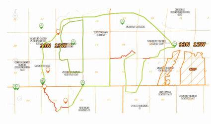
Mapping the damage • Areas of damage from a fire in northern Holt County is designated on a plat map. Holt County Emergency Management director, Deb Hilker, shared the map with supervisors at the June 30 meeting in O'Neill. The small green line indicates boundaries walked or driven by a forest service fire specialist. Red lines are exact boundaries and thick green lines are estimated boundaries
Damage from a lightning strike that ignited grassland and spread to a five- to six-mile-wide fire is still being assessed. Holt County Emergency Management director Deb Hilker presented a map of damaged acres and buildings to Holt County Supervisors at the group's June 30 meeting in O'Neill. Hilker said an estimated 6,600 acres were affected.
The topographical map is interfaced with a plat map to highlight people and acres affected by the fire, which started June 24, in the river bottom between Turkey Creek and Brush Creek, in northern Holt County. According to Hilker, she and Holt County Assessor Tim Wallinger needed a resource to show land most affected.
Hilker said, "The forest service specialist walked a lot of this late Thursday and then they drove some of it and the helicopter took an aerial view. We tried to get the best boundary lines we could."
Seth Petersen, from the forest service, relied on a handheld global-positioning-system device to pinpoint locations.
During the first 12 to 24 hours, Hilker generated Google maps to see who lived where.
"It was just too hot for anybody to get down there," she said.
Hilker reported two buildings, including a small hunting cabin and quonset, were destroyed in the blaze.
"Three different folks lost cattle," she said.
According to Hilker, one family lost 70 pair.
Supervisor Don Butterfield, of Atkinson, asked if individuals who lost livestock would be reimbursed by the state.
Reimbursement from the State of Nebraska would require a statewide disaster declaration.
"I had Bill (Tielke) sign one on Friday to declare a county declaration," Hilker said.
She plans to get a similar declaration from Boyd County, which will assist with reimbursement for aerial services.
A seed plane from the Nebraska Forest Service, used to drop flame retardant, will be based in O'Neill temporarily.
"The plane won't sit here, but all the base materials will be. That takes two semis to get it here and another tanker, they will leave at the airport."
Hilker requested aerial services June 24 and they arrived on scene at between 1 and 2 p.m., June 25. Fire departments are unable to submit a request for aerial support, according to the emergency management director.
"It takes about 24 hours to get helicopters from Lincoln. It just takes that long, the logistics," she said. "Having that seed plane will be based here will be nice thing, just to get a jump start."
A CH47 Chinook helicopter and a UH-72 Lakota helicopter, were utilized to drop water on the blaze.
Thirteen drops were completed, according to Hilker.
"The potential was there for it to get out of hand," Hilker said.
Landowners whose property received fire damage may complete paperwork to possibly have assessed valuations adjusted.
Holt County Assessor Tim Wallinger said paperwork must be completed by July 15.
Assessor's office personnel will determine the number of acres burned on each parcel.
Damage exceeding 20% of a parcel's assessed value can be adjusted
Forms for reporting destroyed real property are available online at revenue.nebraska.gov. Search for Nebraska Form 425.
Landowners with questions about the process may also contact the assessor's office at 402-336-1624.


Reader Comments(0)